Lots and Lots of Problems

Big houses are the minimalist/tiny-living advocate’s whipping boy for many of the world’s ills. Few things are as easy (or big) of a target as a big houses; they take up too much land leading to sprawl, they use too many resources to build and maintain and they have too much storage space for the accumulation for extraneous stuff.

But there’s nothing inherently wrong with big houses. Okay, they take more to clean, and sure the potential for accumulating more stuff than one needs increases, and yes, all things being equal they use more resources to make and maintain (though both of those things can be mitigated significantly with best practices). But, at least to a great extent, a big house can be competitive with a small one in terms of efficiency and resource use.

How can that be, you ask?

As we’ve seen with household size (the number of people living in a home or “dwelling unit”), other factors contribute greatly to housing efficiency. For example, ten 200 sq ft tiny houses with one-person living in each house will probably be a lot less efficient than one 4K sq ft multifamily home with a ten people. Even though they have half the floorspace, the tiny houses, unlike the multifamily home, would each require their own thermal envelopes, plumbing and HVAC systems and so forth. Most importantly, the tiny houses would each have their own lots, swelling the size of the land necessary to accommodate them.

In addition to house and household size, lot size is a critical figure in understanding a house’s overall efficiency.

The average lot size for a new single-family home sold in the US in 2013 was .35 acres or 15,456 sq ft. Combine this with an average household size of 2.54 people and you have the average single-family-home-dwelling American occupying over 6K sq ft of land. [NB: the Census doesn’t distinguish household size between single-family and multifamily homes, so actual household size for single-family homes might be slightly higher]. If we reduced the size of our lots, even if housing size didn’t change or even increased, it could significantly reduce sprawl and improve housing efficiency.

In understanding how lot size affects sprawl, it’s important to understand a lot’s allowable floor area ration or FAR. The FAR is the ratio of gross floor area in relationship to lot size. A 4K sq ft building on a 1K sq ft lot will have a FAR of 4, or conversely a 1K sq ft building on a 4K sq ft lot will have a FAR of .25 and so forth. Typically, FAR is a big deal in cities, where developers want to squeeze every bit of use from a lot’s area.

But FAR has many suburban implications. Consider this: if the average new home in the US is 2,662 sq ft and occupies a 15,456 sq ft lot, it has a FAR of .17. In other words, it uses 17% of the lot it’s built on. But this doesn’t tell the full picture. 17% use of a lot’s area assumes a one story structure. If those 2,662 sq ft are evenly divided between two floors, a home might only take up 8.5% of its lot’s area. The rest of the lot is yard space, driveways, garages (which are sometimes not included in gross floor space), etc. When everyone gets their own mansion, plopped on a big lot, connected to other mansions by wide-laned roads and highways, interspersed with shopping centers with huge parking lots, it leads to more driving, more encroachment on nature, more sprawl.

But again, big houses aren’t the problem. If a big house has a high FAR–either a single family home occupying a small lot or a large home in a multifamily building–it can rival or beat many small homes with low FARs in terms of efficient use of land and location efficiency. Consider that a 200 sq ft tiny house on a bucolic one acre lot would have a FAR of .004, contributing more to sprawl than a McMansion. In achieving efficient housing, smaller house size might be necessary, but it’s far from sufficient.

All of this is to say that efficient housing should not be oversimplified. A big house in the right context can be a great thing. A tiny house in the wrong one can be an energy-gobbling, sprawl-creating terror. The ideal is a hybrid of modest house and lot size, where the area that is consumed is area that is used.

Large Back Yard image via Shutterstock

Luxury Micro-Apartments Come to DC, Transportation Included

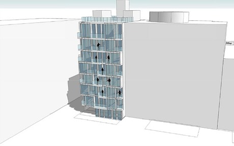
A new micro-apartment building will be going up on the 1400 block of Church St NW in Washington DC. It will have 37 units ranging from 265 to 490 sq ft, according to Brook Rose who, along with Gregg Busch is developing the project. Rose’s specialty is luxury development and he sees the Church St apartments as consistent with that. “We are going to try to make these luxury micro apartments,” Rose told us. The rental apartments will feature floor to ceiling windows and high end finishes. The smallest units, where there is an imperative to have all the furniture work perfectly with the space, will be semi or fully furnished, using transforming furniture by the company Inova. Rents will likely start around $2K.

church_back

The building is a testament to the fact that Washington DC, a city that up until recently had been pretty ambivalent about micro-housing, is changing its tune, as evidenced by the likely micro-apartment development of the Patterson Mansion as well as this one.  But the city’s approval of the Church St building was far from a slam-dunk, having been held up by the Board of Zoning Adjustment (BZA) for a year because of issues around parking.

As we’ve seen here before, one of the primary sticking points for adding density to an area–something that micro-apartments tend to do–is parking. Most residential building requires a certain number parking spots per unit; these can be satisfied by on or off-street parking. Areas that have robust public transportation and walkable streets like San Francisco can often sidestep those requirements or provide minimal parking. But for most parts of the country, it can be a real barrier for development as it was for the Church St building.

Certain members of the BZA were not receptive to the idea of a building without parking, even though Rose was sure there were many “carless urban dwellers” who were “willing to trade space [and their cars] for lifestyle,” particularly in the building’s neighborhood which is along the 14th street corridor, a walkable area with tons of amenities. Rose calls the area “DC’s Soho.” One gesture Rose and Busch made to prove they were serious about creating a carless building was offer car and bike sharing memberships to residents for the duration of their leases (nb: residents would still pay for their use of the car).

The building eventually received the BZA’s narrow approval last month. The developers agreed to provide four parking spaces: two for residents to use for move in/move out and for guests and the other two will be for dedicated for car sharing cars.

But the city made a stipulation that residents could not apply for parkings permit that would allow them to park legally on neighborhood streets. This prohibition will be written into the leases and the developers will periodically check with the DMV to see if any tenants are violating the agreement. In other words, if you live here you cannot have a car.

Of course residents can elect to park in a private garage, but the arrangement seems like a prescient one. For most of the last 60 years, architecture has been bound to parking. Perhaps the Church St development augers a future where architecture and urban planning are designed as much around people as they are cars.

Photographer Captures Poetry and Perils of Sprawl

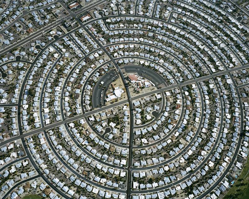
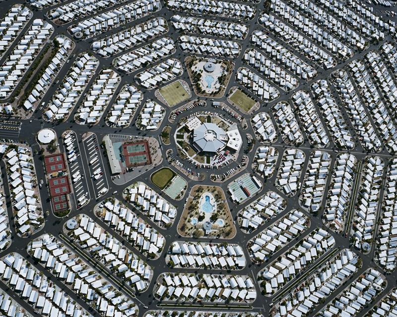
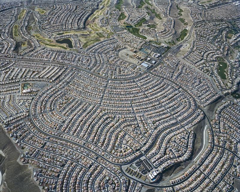
Few things provide context for a place like an aerial view. When we only see what’s in our immediate field of vision on the ground, it’s tough to understand how we fit into the world around us. Gaining this larger perspective is what photographer Christoph Gielen achieves with “Ciphers,” a collection of shots showing suburban sprawl as seen from above. His examples, which are as varied as prisons and retirement communities, show an undeniable visual poetry to the patterned layouts of the homes.

Gielen also brings to attention the environmental impact sprawl, which is almost entirely dependent on cars to access. He writes on his site:

The goal of this work is to connect art with environmental politics and to trigger a discussion about contemporary building trends by looking closely at the ramifications of sprawl – to ask: what is sustainable planning? – particularly at this point in time, when a growing need for new housing is prevalent across the globe.

The images mostly speak for themselves, but one of the things not explicit is location: most of the developments Gielen chooses are former marshes of Florida or deserts of Arizona, Nevada and California–places that, in their natural states, are barely inhabitable are now blanketed with homes.

Sprawl is the byproduct of the notion that there was and always will be unlimited resources–unlimited gasoline to drive us further and further from city centers, unlimited money and materials to keep building and maintaining ever-growing homes, unlimited water to make prairie grasses grow in the desert. In our process of rethinking these misbegotten notions, people like Gielen provide visual demonstrations of where we’re at so that we might determine where we’re heading.

via Treehugger

Love Manhattan? Then You’ll Love Yujiapu

Ah the dream of creating a perfect city–include the best, leave the rest and all you have is perfect living conditions. History is dotted with success stories: Brasilia, Arcosanti, Celebration, Florida–places that testify that making a great place to live is really a matter of connecting dots and constructing a few buildings.

Aforementioned examples notwithstanding, it’s actually tough to make a city from scratch (who’d a’thunk?). Most successful cities get that way because: 1. they are blessed with great geography (NYC, Singapore, Hong Kong, etc); 2. they evolve over time, adapting to their populations’ and eras’ particular needs; and 3. their evolution has created cultural and aesthetic diversity that makes them resilient and interesting.

But don’t let the difficulty of city-building make you think people ain’t gonna try to do it. They do and they are.

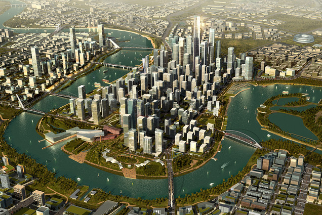
Yujiapu Financial District is one such example. It’s a city being built from scratch in China. It is being made in the likeness of Manhattan, replete with its own Rockefeller Center and One World Trade Center knockoffs. It even has a couple big NYC real estate heavyweights like Tishman Speyer and Rose Rock Group helping construction along. Located about 2.5 hours southeast of Beijing and built on a marshy former fishing village, the city is meant as a high-density haven of global finance, littered with skyscrapers placed along gridded streets…just like Manhattan.

yujiapu-street

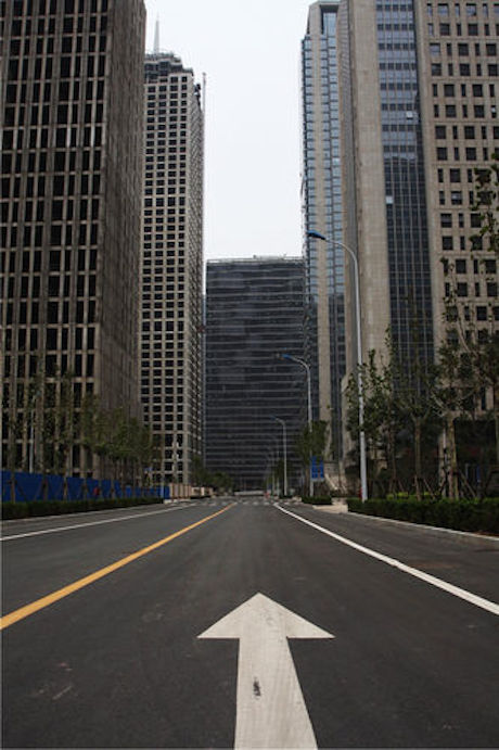
Unlike Manhattan, a city whose modern incarnation started with a small Dutch Settlement 400 years ago, Yujiapu began construction in 2008. Yujiapu’s first building opened two years later and completion is expected for 2019. Also unlike Manhattan, who boasts a population of about 1.7M people, Yujiapu is virtually deserted. And the chances of changing that and replicating Manhattan’s hustle and bustle aren’t looking good.

The city was conceived in the heyday of China’s economic boom. In particular, Yujiapu is near to Tianjin, China’s fourth largest city, whose economy seemed unstoppable ten years ago. But as China and Tianjin’s economy slowed (the latter experiencing a 7% decrease in economic growth in last four years alone), new construction, fueled by hopes of ceaseless economic growth and massive amounts of debt, no longer had occupants. Now buildings like the Country Garden Phoenix Hotel (pictured below), designed to be Asia’s largest, sit fallow along Yujiapu’s untravelled streets.

yujiapu-hotel

We at LifeEdited love our cities. We love walking and biking everywhere. We love the serendipitous encounters that seems to happen all the time along city streets. But making a great city, so far as we can tell, is not a paint-by-numbers proposition. It’s a mutual evolution of planning, place and population. Though it would seem to lack most of those things, we wish Yujiapu well–mostly because that’s a lot of resources for something that might not be used.

Via Bloomberg News and Vagabond Journey

Urban Living Rooms and Why Privacy is Overrated

Humans tend to idealize ample private space: no one to disturb you while you read or surf the web or watch TV or take a nap. Pure peace and tranquility. The reality is something different: no one to disturb you while you read or surf the web or watch TV or take a nap. Pure boredom and inertia.

Few people are truly introverts (at least according to Myers-Briggs); this aligns nicely with living in small spaces. Because small homes lack big private spaces, we can use our “cities as living rooms.” Living outside in our cities is more space efficient and, importantly, more social than holing up in our private living rooms. When’s the last time you unexpectedly ran into a friend in your living room (and no, online encounters do not count)? But let’s face it, typical city furnishings–benches, tables, steps and the occasional lawn–are seldom as comfortable as our living room’s comfy environs. A couple projects are changing that situation one sofa at a time.

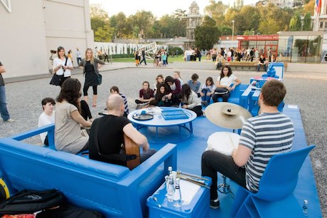
The first project is the aptly-named Urban Living Room. The project is the brainchild of artist and organizer Studio ID Eddy, Powerboat and designer Bas Kortmann. The three made a popup living room that, according to their website, “challenges the way public space is treated.” The living room, set up in busy city centers, offers both temporary repose where strangers and friends can meet; it also offers a space for performances and workshops (does your living room have that?).

urban-living-room-istanbul

The furniture serves as both a place to rest and design showcase for Dutch designers. The smurf-blue color is a way to provide visual relief from the cityscape; it is also the color of the polyurethane coating that protects the furniture from the elements. ULR tours throughout Europe. Its next stop is Barcelona. See its schedule here.

free-convo

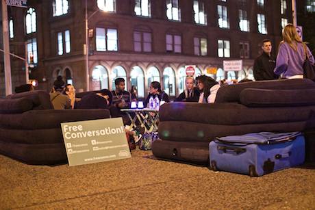
Closer to home is “Free Conversation” which is like a living room pre-populated by a group of interesting/interested folks. We passed by FC in Washington Square Park the other day (full disclosure: my squirrely son prevented my participation). They had several comfy looking inflatable sofas set up where people were chilling and talking.

The project’s co-founders Mike Scotto and Tony Cai are a couple tech wonks who saw the need for folks to hang out and connect on a level deeper than exchanged texts messages. When people get to FC, they are asked to put down their phones and just connect. This is a great thing. Even though cities like New York are ideally set up for serendipitous meetings, the likelihood of that happening is greatly lessened when our heads are glued to our phones. FC brings back the unplanned meeting. All we have to do is stop and sit–something that is occasionally harder to do than it sounds.

Sprawl Messed Up

Forgive us if we seem like anti-sprawl-ites, but evidence keeps mounting that sprawl is neither planet nor people friendly. A study commissioned by Smart Growth America called “Measuring Sprawl and its Impact” looked at 221 metropolitan areas and 994 counties in the United States. The study sought to find out if there were connections between sprawl and social issues. Here’s what University of Utah professor Reid Ewing and doctoral research assistant Shima Hamidi–the study’s main authors–found out:

Several quality of life factors improve as [sprawl] index scores rise. Individuals in compact, connected metro areas have greater economic mobility. Individuals in these areas spend less on the combined cost of housing and transportation, and have greater options for the type of transportation to take. In addition, individuals in compact, connected metro areas tend to live longer, safer, healthier lives than their peers in metro areas with sprawl. Obesity is less prevalent in compact counties, and fatal car crashes are less common.

More specifically:

  • Traffic accidents were slightly more frequent in compact areas, but there were twice as many fatal accidents in sprawling areas.
  • Residents in sprawling cities spent more on combined transportation and housing expenses than compact cities, 52.1% and 51.1%, respectively.
  • Compact city dwellers had a longer life expectancy: 78.4 years versus sprawlers 77.7 years. Moreover, “For every doubling in an index score, life expectancy increases by about four percent. For the average American with a life expectancy of 78 years, this translates into a three-year difference in life expectancy between people in a less compact versus a more compact county.”
  • The average sprawling man was two pounds heavier than the compact one.
  • In terms of economic mobility, “For every 10 percent increase in an [sprawl] index score, there is a 4.1 percent increase in the probability that a child born to a family in the bottom quintile of the national income distribution reaches the top quintile of the national income distribution by age 30…For example, the probability of an individual in the Baton Rouge, LA area (index score: 55.6) moving from the bottom income quintile to top quintile is 7.2 percent. In the Madison, WI area (index score: 136.7) that probability is 10.2 percent.”

The aforementioned sprawl index is a scale based on “four primary factors—residential and employment density; neighborhood mix of homes, jobs and services; strength of activity centers and downtowns; and accessibility of the street network,” according to the study. An index score of 100 represents the national average. Anything above 100 was considered compact and below, sprawl.

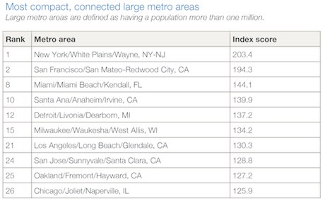
Predictably, with a score of 203.4, NYC was the most compact large metro area. Predictably as well, with a score of 76.7, Houston ranked as the most sprawling large metro area; in fact, eight of the ten most sprawling large cities were in the south (technically, the other two cities rounding out the bottom ten–Riverside-San Bernardino/Ontario, CA and Prescott, AZ–are southern cities).

most-compact-citiesmost-sprawling-cities

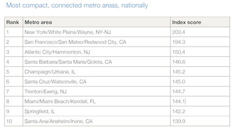
There was a pretty big drop off from second ranked San Francisco at 194.3 to third ranked Miami, at 144.1. These scores hint at how sprawl still pervades most American metro areas. Despite many indicators pointing to a more compact, urban America, there was a 1.4% increase in sprawl between 2000-2010. With few exceptions, it would seem as though we have a long road ahead of us before we offset years of urban planning predicated on cars (no pun intended).

most-compact-cities-all

Secondly, the names of cities that ranked below NYC and San Francisco–irrespective of size–were not who we thought they’d be: Atlantic City, Santa Barbara, Champaign/Urbana and Santa Cruz bested places like Boston, Chicago and Los Angeles. Of course, this is macro-data and cannot account for specific comparisons, e.g. living and working in the Loop of Chicago will be less sprawling than living on the edges of town in Santa Cruz (the study could not get data at those discreet levels and notes as such). Nonetheless, it shows there are still compact, walkable, economically viable cities outside the ones we typically think of.

We’re not shy about expressing our belief that much of the world (and the US in particular) would be better off living a little closer, a little smaller and driving a lot less. At least in a general way, the SGA quantifies some of the social and public health benefits of this sort of living.

Via Wall Street Journal

Tabula-Rasaburg

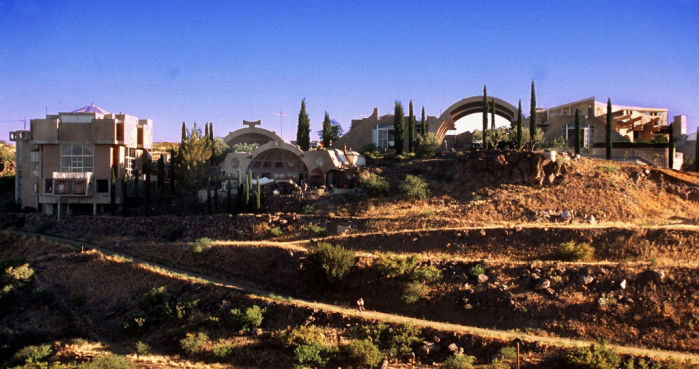
Many, if not most major cities have been around for some time. NYC dates from the 17th Century, San Francisco from the 19th, London from the Roman Empire. As such, these and other cities are burdened with the unwanted inheritances of past lives: ancient and crumbling architecture, archaic street grids, sprawled-out and mass-transit-proof city plans and so on. Arcosanti, an urban experiment built on the tabula rasa of the Arizona desert, was to be a city without a past–a city that would succeed because it was guided and designed by principles, not ghosts.

arcosanti-panorama

Arcosanti first broke ground in 1955 in a location 70 miles north of Phoenix. The project was the brainchild of Italian-American architect Paolo Soleri. It was meant to be a living embodiment of the concept he called arcology, the meeting of architecture and ecology. The city sought to adhere to design principles that would perfectly alloy the best of the city (density, social living), country (access to nature) and sustainable living (resource conservation). Here is an example of the “proximity” principle from the Arcosanti site:

Arcosanti’s design provides an efficient and lively urban environment by physically connecting a mix of activities such as living, working, learning and leisure. In this way efficient and equitable access to most of the city’s amenities and are available within minutes. Although life in such a setting will be intense and exciting, at times it could be taxing on individuals. For this reason, Arcosanti also features immediate access to open space and nature, to provide opportunities to decompress.

Other principles include things like urban scale, less consumption and elegant frugality (full list here).

Arcosanti_vaults

The town occupies a space of 25 acres and has 13 buildings, most of which were built between 1955 and 1974. The architecture, which was to embody the principles and bring people together, is littered with common spaces that look like a Roman forum as interpreted by the set designer of Battlestar Galactica (the one from the 70s).

Over the course of its life, there have been anywhere from 50 to 150 people living there at one time, fluctuations attributable to student populations who have used the town as a research site.

The town was intended to eventually house and support 5K people. That intention, for a multitude of reasons, was never fulfilled. Some of those reasons, like a spartan, toilsome daily routine, and a cement building composition that baked in the sun and froze in the winter, were specific to Arcosanti. Others were characteristic of many total cities (e.g. Brasilia), where the autocracy of principles and a singular, exclusionary vision left little room for the cultural and formal flexibility that makes successful cities succeed.

Today, the town’s main “industry” is handmade bells. As of a couple years ago, there were 56 full-time residents. Arcosanti still hosts students and tourists (you can book one of their rooms through their website). But notions of Arcosanti as a model for the future have mostly evaporated like water in the desert (who knew making a city could be so hard?). All that said, we love a good experiment and think Arcosanti was, and to some extent isa bold one worth knowing about…if not living in.

Seattle’s Urban Boom

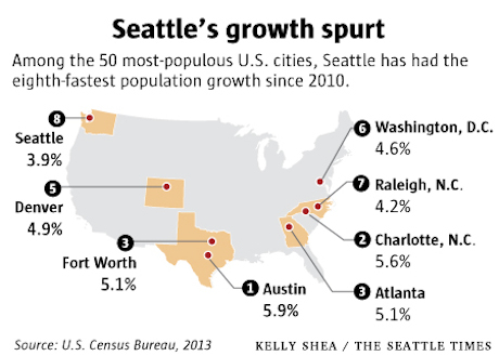
Forget NYC and San Francisco as the American leaders in smart urban growth. Seattle is where it’s at. The two former cities–with their tight geographies and urban grids conducive to walking, public transport and compact, efficient living–have always packed people in. But Seattle’s growth was more emblematic of many American cities, where, throughout the 20th Century, suburban sprawl reigned supreme. For 100 years, the suburbs of King County outpaced the growth of the city of Seattle (which, incidentally, is the King County seat). A trend that appears to be changing.

The first sign was in 2010, when the city of Seattle matched King County suburban growth. Then between 2011-2012 Seattle grew at a rate 25% faster than King County.

seattle-growth

Some attribute this trend to the aftermath of the housing bust–young people couldn’t “graduate” to the burbs like their parents did in the past. But the trend is hardly limited to Seattle. From DC to Denver to Atlanta, people are choosing city living–a choice that may be more than sloppy seconds to the suburbs.

fyiguy-popgrowth-map-2

The Seattle Times speculates about the possible motivations behind this movement:

We might be witnessing a major demographic shift, with younger people rejecting a culture of sprawl and car-dependency associated with suburbs, and instead choosing the lifestyle offered by dense, walkable cities…Signs of Seattle’s success are not difficult to spot. Everywhere you look there seems to be a new apartment building under construction. As reported in The Seattle Times, more apartments were opened in 2013 than in any of the previous 20 years.

Seattle bears this out. Least we forget, the city is perhaps the epicenter of the micro-apartment movement (often to the chagrin of many Seattleites). These tiny apartment forgo large interiors and parking spaces for central locations and affordability. As of last year, there were at least 47 micro-apartment buildings throughout the city; these developments are unique in that they Seattle convert low-to-medium density neighborhoods into higher density ones.

Of course Seattle’s growth can’t be solely attributed to micro-housing. It does show Seattle’s regulatory willingness to centralize populations–something that can’t necessarily be said for NYC, for example, a city that still has a 400 sq ft minimum size for new apartments.

The city of Seattle has 7,402 people per square mile. Compared to NYC and San Francisco–27,550 and 17,620 people per sq mile respectively–that number is not earth shattering. But NYC and San Fran both enjoy significant geographical constraints as well as infrastructures that were developed well before the car came into widespread use. For them, dense, walkable, easily traversed cityscapes are natural. Seattle, whose infrastructure grew up to a greater extent around the car, was more susceptible decentralization, making recent developments all the more impressive. It shows that a city’s growth need not be dictated by nature–that how a city nurtures development plays a critical role in smart growth and more livable cities.

Via Seattle Times

Bike Lanes in the Sky

Across the world, bicycles are quickly gaining ground as the transportation of choice–if they weren’t already. The reasons are clear: they’re exceedingly efficient and green, quick and keep you healthy. Their one big drawback is that some folks are (justifiably) skittish about sharing the roads with multi-ton masses of steel moving at great velocities. While bike lanes that skirt normal roadways are better than nothing, they still leave cyclists pretty exposed. What if there were separate, elevated lanes just for bikes? This is an idea many are considering.

Architizer recently did a roundup of some of these lanes, both existing and proposed, that keep bikes high and away from the dangers of cars.

Of course, leading the way are the Dutch, who have built a floating bike lane in Eindhoven called the Hovenring (in video above). Not exactly an extended lane, the Hovenring is a 236 ft elevated ring floating above a highway, bridging other bike lanes that skirt the highway.

foster-and-partners copy

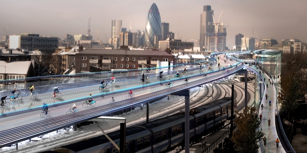
London SkyCycle by Foster + Partners (pictured above) is an ambitious plan that proposes a 136 mile network lofted above existing suburban rail lines. There would be 200 entry points, serving 2M people that live in the area it’d cover. According to F + P, following railways is ideal because the tracks were originally built for steam engines, who had to find the easiest, flattest route around the city.

london-sky-cycle

Velo-City in Toronto, Ontario by Chris Hardwicke proposes a similarly extensive network of bike lanes as SkyCycle. Unlike that latter project, Velo-City has a covered bikeway, protecting cyclists from the elements–probably the second biggest deterrent to bike riding next to safety. Unfortunately, Velo-City was proposed in 2006 and seems to have met its fate that year as well.

If all of this sounds a bit fantastic, consider that building an elevated bikelane is a far smaller engineering challenge than building an elevated road–or maybe even a terrestrial one. Without the abuse of heavy cars and semis, their upkeep would be far cheaper than normal roads. If only we had a bicycle lobby in Washington….

Check out more on Architizer

City Where Architects Dare Not Tread

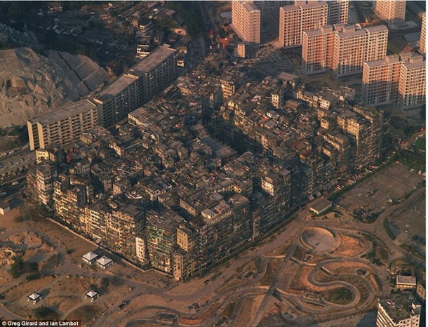
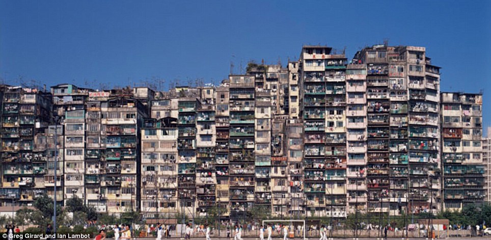
At LifeEdited, our preference for urban planning leans toward density. As a general rule, greater density is more energy efficient, promotes walking and some even say happiness. But like anything, there can be too much of a good thing. And few places in the annals of history have a greater excess of density goodness than Hong Kong’s Kowloon Walled City. At one point, the city held 33K residents on an area of 0.0102 sq mile–that would be 3.2M people per sq mile! For comparisons sake, mainland Hong Kong has about 17K people per sq mile and NYC has 27K.

The city had its beginnings as a Chinese fort, erected as early as the 10th Century. The labyrinth of buildings that most people associate with Kowloon started in 1933, when the HK government demolished all but a few structures, displacing the then 436 residents. In 1940, Japan, occupiers of HK, destroyed the eponymous city wall creating a sort of tabula rasa of urban planning chaos. After Japan’s surrender, 2K Chinese refugees moved into the city. British colonial powers adopted a “hands-off” policy toward the city. This laissez-faire governance led to several decades of extreme crime, with Chinese Triad gangs running the city from the 50s through the 70s.

The hands off approach also led to the improvisational architectural scheme. There were over 300 hundred 10-14 story buildings built mostly in the 60s and 70s. All these building went up without pesky architects, urban planners or governmental oversight. 60% of homes were only 250 sq ft and many lacked utilities.

Photographers Greg Girard in collaboration with Ian Lamboth spent five years in Kowloon before it was demolished in 1992. The pictures are great as they capture more than the dizzying maze of Kowloon’s exterior; they also peer inside the city, looking at the homes, businesses and alleys where tens-of-thousands of people lived.

Images via Daily Mail UK